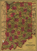
Historic Indiana Maps
Maps are often beautiful illustrations of our history, the human-environmental interaction, and natural features of our state and its communities. Maps record settlement patterns, political boundaries, transportation routes, and land ownership. Maps contain invaluable information for historians, genealogists, and citizens. The resources in this collection are historical maps of Indiana, its counties and cities, from the collections at Indiana University. Efforts were made to represent various areas of our state, but selection was based on G. K. Hall and Co.'s Checklist of Printed Maps of the Middle West to 1900 Volume 3 covering the state of Indiana.